Must be those atmospheric rivers I've heard about in the past.
West Coast Fire Thread
-
ken_sylvania
- Posts: 2245
- Joined: Sat Sep 14, 2024 5:41 pm
- Affiliation: Mennonite
-
Ken
- Posts: 21863
- Joined: Thu Jun 13, 2019 12:02 am
- Location: Washington State
- Affiliation: former MCUSA
Re: West Coast Fire Thread
Idiots....
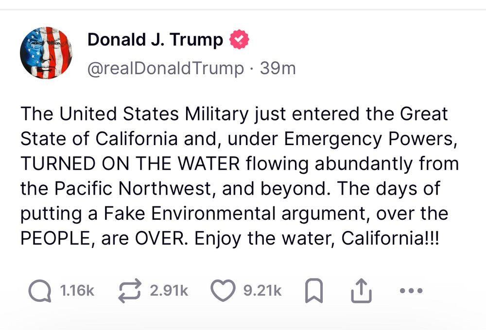
We now know what "turning on the tap" actually means in the real world. This man has no idea what he is actually doing: https://sjvwater.org/decision-to-dump-w ... -scramble/
We now know what "turning on the tap" actually means in the real world. This man has no idea what he is actually doing: https://sjvwater.org/decision-to-dump-w ... -scramble/
Decision to dump water from Tulare County lakes altered after sending locals into a mad scramble
By Lois Henry ● News ● January 30, 2025
Water managers were relieved Thursday evening after the Army Corps of Engineers agreed to back off of a sudden decision earlier in the day to dump massive amounts of water from Kaweah and Success lakes.
Water managers said they got about an hour’s warning from the Army Corp’s Sacramento office to expect the Tule and Kaweah rivers to be at “channel capacity” by Thursday night.
Channel capacity means the maximum amount of water a river can handle. For the Kaweah, that’s 5,500 cubic feet per second and for the Tule, it’s 3,500 cfs.
Those levels were last seen, and surpassed, during the 2023 floods, which destroyed dozens of homes and businesses and caused significant damage to infrastructure.
“We were able to get them to back off that,” said Eric Limas, General Manager of the Lower Tule River and Pixley irrigation districts, of the Army Corps. “They’ll still be releasing water sometime tonight, but it will be a smaller amount, which will increase tomorrow.”
Limas and Tulare Irrigation District General Manager Aaron Fukuda were unsure how high releases would ultimately go and for how long but Kaweah has about 27,000 acre feet and Success about 5,000 acre fee that are above levels allowed by the Army Corps during winter.
Water managers will continue working with the Army Corps to limit the amount of water released from the lakes, Fukuda said.
“We’re still trying to wrap our minds around the numbers that made this happen,” Fukuda said. “We haven’t received much information from the Army Corps, just very vague answers.”
Rick Brown, chief public affairs officer for the Sacramento office of the Army Corps, would only say that levels in both lakes were “currently in the flood control space.”
He directed further questions to the Army Corps’ headquarters, which did not return an email Thursday asking: Who made the decision to release the water? Why? Why so suddenly? And why weren’t safety personnel notified?
Some people interviewed for this story speculated that the move was political on the part of the new administration, a kind of water “flex,” but declined to elaborate.
Tulare County Sheriff Mike Boudreaux said one of his officers had heard about the pending releases through the grapevine late Thursday afternoon and they were getting conflicting information through the evening.
The Tule River goes through the heart of Porterville and there are a number of agreements about how releases should be made, including notifications to first responders, which is why Porterville didn’t flood in 2023.
Army Corps reservoirs are required to be drawn down every fall to make room for winter storms and later runoff.
But the Army Corps typically works with downstream agricultural users to allow them to keep a bit more water in the lakes to hedge against dry years, such this one is shaping up to be.
Kaweah River Water Master Victor Hernandez said Lake Kaweah’s winter capacity is 12,000 acre feet, but had been allowed to go up to 39,000 acre feet after an aerial snow survey showed the watershed currently only has another 45,000 acre feet in snow cover.
“Even if everything came down at once, it would only be enough to fill the reservoir halfway,” he said. “We were on track with the Corps working with the models and forecasts and doing our planning and then I get a call at 2:15 p.m. telling me they were going to channel capacity.”
Hernandez was floored.
“In 25 years, I’ve never seen anything like this,” he said. “I was given no explanation at all.”
Before they got word of the Army Corp’s decision to release less water, Hernandez, Fukuda and Limas were planning for the worst.
Hernandez had already notified managers on the old Tulare Lake Bed to expect possible flood water. And Limas and Fukuda had crews ready to work through the night stripping out weirs and channel guides, which were only recently rebuilt after the 2023 floods, to keep the water moving.
“Normally, these kinds of flood releases are done with a lot of notification and coordination,” Fukuda said. “I’ve been doing this 18 years and have never seen something like this.”
The Army Corps also operates Isabella and Pine Flat lakes on the Kern and Kings rivers, respectively.
Kern River Watermaster Art Chianello and Kings River Watermaster Steve Haugen both said they had not received notice of flood releases from Isabella and Pine Flat.
But neither of those lake levels are above their winter allowance, Haugen said.
2 x
A fool can throw out more questions than a wise man can answer. -RZehr
Re: West Coast Fire Thread
I thought you said there was no "tap" to turn. Would not the writer be delusional writing about something that does not exist?
2 x
Try hard not to offend. Try harder not to be offended.
I think I am funnier than I really am.
I think I am funnier than I really am.
-
Ken
- Posts: 21863
- Joined: Thu Jun 13, 2019 12:02 am
- Location: Washington State
- Affiliation: former MCUSA
Re: West Coast Fire Thread
What I said was that there are no taps to turn between the Pacific Northwest and CA because there are no canals or aqueducts between the PNW and CA. This is a dam system in central CA.
0 x
A fool can throw out more questions than a wise man can answer. -RZehr
Re: West Coast Fire Thread
I keep hearing how CA has a terrible drought. Apparently they simultaneously have a drought, risk of floods, too much water, and fires.
0 x
-
Ken
- Posts: 21863
- Joined: Thu Jun 13, 2019 12:02 am
- Location: Washington State
- Affiliation: former MCUSA
Re: West Coast Fire Thread
It is a very big state with dozens of different climates and watersheds from rain forests to deserts. The distance from Crescent City on the Oregon border to San Diego on the Mexican border is 850 miles. That is about the same distance as Philadelphia PA to Jacksonville FL.JohnH wrote: ↑Fri Jan 31, 2025 9:00 pmI keep hearing how CA has a terrible drought. Apparently they simultaneously have a drought, risk of floods, too much water, and fires.
0 x
A fool can throw out more questions than a wise man can answer. -RZehr
-
Ken
- Posts: 21863
- Joined: Thu Jun 13, 2019 12:02 am
- Location: Washington State
- Affiliation: former MCUSA
Re: West Coast Fire Thread
Here is the current drought map for California. The reservoirs in the high Sierra capture snow melt during the winter and release it for irrigation during the summer. And also function as flood control. So it was egregiously stupid to start draining reservoirs now in the middle of winter just because Trump wanted to "open the tap" The water they dumped is used for summer irrigation in the San Juaquin Valley, not Los Angeles.

1 x
A fool can throw out more questions than a wise man can answer. -RZehr
Re: West Coast Fire Thread
You do realize why water was desperately needed right?Ken wrote: ↑Fri Jan 31, 2025 11:40 pmHere is the current drought map for California. The reservoirs in the high Sierra capture snow melt during the winter and release it for irrigation during the summer. And also function as flood control. So it was egregiously stupid to start draining reservoirs now in the middle of winter just because Trump wanted to "open the tap" The water they dumped is used for summer irrigation in the San Juaquin Valley, not Los Angeles.
1 x
-
Ken
- Posts: 21863
- Joined: Thu Jun 13, 2019 12:02 am
- Location: Washington State
- Affiliation: former MCUSA
Re: West Coast Fire Thread
The reservoirs that Trump ordered drained were in the central Sierra nowhere near Los Angeles. They fill them in the winter to provide irrigation water to the San Juaquin Valley in the summers. They are not connected to Los Angeles so dumping that water into the rivers in January was a pointless waste of summer irrigation water.
And Los Angeles is not actually short of water. The fire fighting infrastructure built decades ago is simply not up to the task of fighting these enormous climate-change fueled fires. How do you fight fires on hillsides in a city like Los Angeles? You build massive cisterns and water tanks on the tops of hills to provide water supply during fires. But the system built long ago wasn't designed for these sorts of massive fast-spreading new fires. And residential hydrants designed for fighting individual house fires are not really adequate for such massive urban wildfires. So while the region has plenty of water supply, some of the cisterns for fire suppression ran out of water.
What is the solution? Tax and spend billions more dollars to expand the system to deal with the worst case fire scenario? Perhaps. How much do you want to spend and what is the worst case scenario? I expect they will be pouring more money into fire infrastructure but how much is enough? No one actually knows. A big part of the problem is the way Los Angeles neighborhoods are built with sprawling single family homes tucked into wooded landscapes. That is probably no longer sustainable. Barcelona has a very similar climate and biome but doesn't get the same fires because it is much more dense with a lot less flammable building materials. Los Angeles could build like Barcelona if they wanted. But it would look very different.
Take earthquakes as another example. Los Angeles building codes require that new buildings be designed to withstand a 7.0 magnitude earthquake on the Richter Scale. But the faults passing through Los Angeles could produce earthquakes of 7.5 magnitude and the nearby San Andreas fault could produce earthquakes in the 8.0 range which is 10-times stronger than a 7.0. Should Los Angeles design for 8.0 magnitude earthquakes? That might triple or quadruple the cost of building. Is that worth it? Maybe there are just better and safer places to live than the chapparal hills of Southern California or the Gulf Coast of Florida.
1 x
A fool can throw out more questions than a wise man can answer. -RZehr